


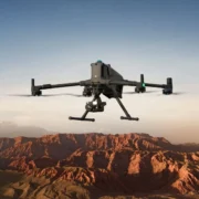
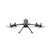

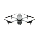
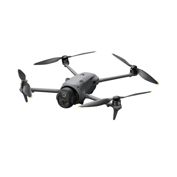
Push Beyond Limits with the DJI Matrice 400 Flagship Drone
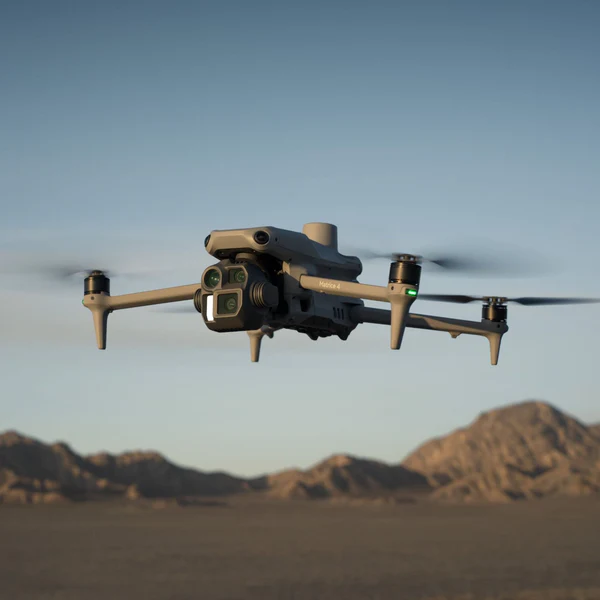
The DJI Matrice 400 isn’t just another step forward—it’s a full leap into the future of aerial operations. Built for demanding professionals who need more than just flight time, this flagship UAV delivers unmatched versatility, advanced autonomy, and rock-solid reliability across every mission profile.
Whether you’re tackling high-stakes search-and-rescue, precise surveying, or complex industrial inspections, the M400 gives you the endurance and intelligence to push farther, longer, and smarter.
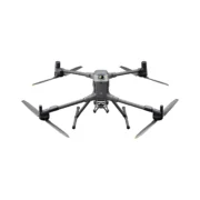
With a flight time of up to 59 minutes—measured under real payload conditions—the M400 redefines operational efficiency. Seven payload mounting points, four E-Port V2 interfaces, and a reinforced 6 kg max payload capacity give you the freedom to configure for any job, any day.
Its robust obstacle sensing system—powered by rotating LiDAR, mmWave radar, and full-color low-light vision—can detect thin wires in the rain, fog, or darkness. This isn’t an upgrade. It’s a new class of capability.
Drone Highlights
- DJI’s most capable enterprise drone to date
- Up to 59-minute flight time with real-world payloads
- 6 kg payload capacity with seven mounting points and four E-Port V2 interfaces
- Rotating LiDAR, mmWave radar, and fisheye vision for all-angle obstacle sensing
- 25 m/s max cruise speed with obstacle avoidance enabled
- 40 km max range via O4 Enterprise Enhanced transmission
- Dual 4G dongles and sub-2 GHz backup for signal redundancy
- Airborne signal relay mode for extended ops in complex terrain
- IP55-rated weather resistance and wide −20°C to 50°C operating range
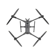
Engineered for Next-Level Autonomy and Endurance
The Matrice 400 is equipped with DJI’s most advanced sensor fusion suite to date. It combines 360° rotating LiDAR with mmWave radar and starlight-grade fisheye cameras to navigate high-risk environments with ease.
Whether you’re operating over rugged terrain, dense cityscapes, or offshore vessels, the M400 can execute terrain-following routes, geometric mapping paths, and complex AR-assisted maneuvers with confidence and consistency.

Its O4 Enterprise transmission system delivers full HD video at 60 fps from up to 40 km away, with automatic fallback to sub-2 GHz frequencies and support for dual 4G Cellular Dongles to maintain signal in the harshest RF environments.
It even supports airborne relay mode—turning one M400 into a flying repeater to extend the range of another drone in difficult terrain.
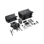
Compatible Payloads
The Matrice 400 supports an extensive range of DJI and third-party payloads designed to tackle advanced missions with precision. Modular architecture means fast loadout swaps and seamless integration across tools, sensors, and compute power.

- Zenmuse H30 / H30T: All-in-one 5-sensor suite with zoom, wide, thermal, laser rangefinder, and NIR. Delivers unmatched performance for surveillance, SAR, and tactical missions—day or night.
- Zenmuse L2 LiDAR: Captures 240,000 points per second for accurate, efficient 3D modeling. Ideal for corridor mapping, construction, and forestry analytics.
- Zenmuse P1 Photogrammetry: 45MP full-frame camera with ultra-fast capture intervals for orthomosaics, digital twins, and topographic maps.
- Zenmuse S1 Spotlight: High-intensity 32-watt LEP lighting—cut through darkness for search missions and infrastructure inspections.
- Zenmuse V1 Speaker: Broadcast messages at 114 dB for real-time communication during emergency response or public safety deployments.
- Manifold 3: AI-powered onboard computer delivering 100 TOPS for real-time object recognition, custom models, or edge computing tasks.
- Third-Party Payloads: Integrates seamlessly via DJI’s PSDK and E-Port standards—supporting multispectral sensors, gas detectors, samplers, and tethered systems.
Use Cases in the Field
- Law Enforcement & SAR: Detect thermal signatures, issue live voice commands, and light up dark zones for tactical or rescue missions.
- Disaster Response: Maintain constant terrain-following surveillance with optional tethered power for extended operations day or night.
- Maritime Patrol: Launch from moving vessels, identify targets over water, and fly smart return-to-ship protocols.
- Mapping and Survey: Speed up ortho, slope, and linear capture with centimeter accuracy—now with more coverage per flight.
- Energy Sector: Perform close-in inspections of wind turbines, substations, and solar arrays with stable data acquisition and minimal downtime.
- Scientific & Environmental: Collect gas, water, or UV readings with custom sensors, and run onboard AI classification models using Manifold 3.
Every Matrice 400 we have here at buy4tdrones is mission-ready, with the right payloads, accessories, and support to make a difference from day one.
Reach out to buy4tdrones today for a quote, product walkthrough, or to build a custom M400 bundle tailored to your specific needs.
Aircraft
- Takeoff Weight (with propellers): Without Batteries: 5020 ± 20 g; With Batteries: 9740 ± 40 g
- Max Takeoff Weight: 15.8 kg
- Dimensions: Unfolded: 980×760×480 mm; Folded: 490×490×480 mm; Carrying Case: 779×363×528 mm
- Max Payload: 6 kg
- Propeller Size: 25 inches
- Diagonal Wheelbase: 1070 mm
- Max Ascent Speed: 10 m/s
- Max Descent Speed: 8 m/s
- Max Horizontal Speed: 25 m/s
- Max Takeoff Altitude: 7000 m
- Max Flight Time: 59 minutes
- Max Hover Time: 53 minutes
- Max Flight Distance: 49 km
- Max Wind Resistance: 12 m/s
- Max Yaw Angular Velocity: 100°/s
- Max Pitch Angle: 35°
- Operating Temperature: –20° to 50 °C
- GNSS: GPS + Galileo + BeiDou + GLONASS*
- Hovering Accuracy:
Vertical: ±0.1 m (vision), ±0.5 m (satellite), ±0.1 m (RTK)
Horizontal: ±0.3 m (vision), ±0.5 m (satellite), ±0.1 m (RTK) - RTK GNSS Accuracy: 1 cm + 1 ppm (H), 1.5 cm + 1 ppm (V)
- RTK Heading: Better than 2°
- ADS‑B In: Range: 20 km
- Internal Storage: N/A
- Ports: USB‑C Debug, E‑Port V2 ×4, Cellular Dongle 2 ×2
- Propeller Model: 2510F
- Beacon: Built-in
- Ingress Protection: IP55
Gimbal
- Max Payload (Single Connector): 1400 g
- Max Payload (Dual Connector): 950 g
- Max Payload (Third Connector): 3 kg (quick‑release), 6 kg (screw lock)
Sensing System
- Sensors: Omnidirectional binocular vision, LiDAR, infrared, mmWave radar
- Forward/Backward: Range: 0.4–21 m; Detection: 0.4–200 m; FOV: 90°×90°
- Lateral: Range: 0.6–21 m; Detection: 0.5–200 m; FOV: 90°×90°
- Downward: Range: 0.5–19 m; FOV: 160° front/rear, 105° sides
- Rotating LiDAR: Range: 0.5–100 m; FOV: 360°×58°
- Upper LiDAR (3D ToF): Range: 0.5–25 m; FOV: 60°×60°
- Infrared: Range: 0.3–8 m; FOV: 60°×60°
- mmWave Radar: Range: 36–50 m; FOV: ±45°
FPV Camera
- Resolution: 1080p
- Field of View: DFOV 150°, HFOV 139.6°, VFOV 95.3°
- Frame Rate: 30 fps
- Night Vision: Starlight-grade
Video Transmission
- System: DJI O4 Enterprise Enhanced
- Live View: 3‑channel 1080p/30fps
- Frequencies & Power: Multiple bands including 902–928 MHz, 2.4 GHz, and 5.8 GHz
- Max Distance: 40 km (FCC), 20 km (CE)
- Performance with Interference: 1.5–40 km depending on strength
- Max Download Speed: 80 Mbps
- Antennas: 8 WLAN, 2 sub2G, 4G ×4
- Other Features: Dual Control, Cellular Dongle support
Battery
- Model: TB100
- Capacity: 20254 mAh
- Voltage: 48.23 V
- Max Charging Voltage: 54.6 V
- Cell Type: Li-ion 13S
- Energy: 977 Wh
- Weight: 4720 ± 20 g
- Charging Temp: 5–45 °C
- Discharging Temp: –20–75 °C
- Heating: Onboard & Station Support
- Discharge Rate: 4C
- Max Charging Power: 2C
- Cycle Count: 400
Battery Station
- Model: BS100
- Weight: 11.8 kg
- Dimensions: 605×410×250 mm
- Supported Batteries: TB100 / TB100C / WB37
- Operating Temperature: –20–40 °C
- Input: 100–240 V AC
- Output:
TB100: up to 2184 W
WB37: 52 W
USB‑C: up to 65 W - Charging Channels: 3 TB100 & 2 WB37
- Modes: Ready‑to‑Fly, Standard, Fast, Silent
- Charging Time: 45–110 min depending on mode and voltage
Remote Controller (DJI RC Plus 2)
- Video Transmission: DJI O4 Enterprise Enhanced
- Max Distance: 40 km (FCC), 20 km (CE)
- Frequencies: Multiple bands
- Antennas: 2T4R dual‑band + sub2G 2T2R
- Wi‑Fi: 802.11 a/b/n/ac/ax, up to 1774.5 Mbps
- Bluetooth: 5.2
- Screen: 7.02″, 1920×1200, 1400 nits
- Battery: Internal (6500 mAh) + Optional External (4920 mAh)
- Runtime: 3.8 h (internal), 7 h (w/ external)
- Charging Time: ~2 h
- Storage: 8 GB RAM + 128 GB + microSD
- Ports: HDMI, SD, USB‑C (PD), USB‑A
- Weight: 1.15 kg
- Dimensions: 268×163×94.5 mm
- GNSS: GPS + Galileo + BeiDou
- OS: Android 11
Supported Accessories
- Zenmuse H30/H30T/L2/P1
- Zenmuse S1, V1
- Manifold 3
- DJI RC Plus 2 sub2G SDR
- Cellular Dongle 2
- D‑RTK 3 & 2
- X‑Port, E‑Port V2
- SkyPort V3 Adapter
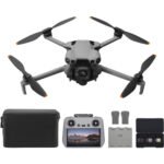
- 1x Aircraft (with propeller holder)
- 1x Carrying Case
- 2x Propellers (Pair)
- 6x Propeller Washers and Screws
- 1x Remote Controller (with DJI RC Plus 2 sub2G SDR Module)
- 1x Power Cable
- 1x Remote Controller Strap and Bracket (with two screws)
- 1x WB37 Intelligent Battery
- 2x Landing Gear
- 1x USB-C to USB-C Cable
- 1x Screws and Tool Set
- 1x Cleaning Tool Set
- 1x Rubber Port Covers and Screws
- 4x Gimbal Damper
| Option1 |
Option1 |
|---|

Reviews
There are no reviews yet.